
Beyond the Highway: An independent urban design study exploring alternative futures for the historic core of Marble Falls, Texas
Planning ⋅ Texas Hill Country
Like many Texas Hill Country communities, Marble Falls is entering a period of profound opportunity and change. Decisions made over the coming decades regarding transportation, land use, infrastructure, and environmental stewardship will help determine the long-term character and economic trajectory of the community.
U.S. Highway 281 currently carries approximately 36,000 vehicles per day through the city. What was once a vital economic lifeline increasingly functions as both a transportation corridor and a significant barrier between portions of the historic core. At the same time, regional growth pressures—including transportation, industrial, and resource extraction activities—continue to influence environmental conditions, public health, and quality of life throughout the region. These trends raise an important question: how can future growth strengthen the character, prosperity, and livability of Marble Falls while preserving the qualities that have historically made it attractive?
Beyond the Highway is an independent urban design exploration intended to examine that question. This study is not a formal plan, nor is it associated with any public agency, elected body, or private client. Rather, it represents a professional exercise in long-range thinking about how Hill Country communities might evolve over the coming decades.
The study explores the possibility of a more connected, human-scale, and economically vibrant community organized around a strengthened historic core. It considers how transportation systems, parks and open space networks, pedestrian and bicycle circulation, land use patterns, civic investment, and environmental systems might best work together to create a more resilient and dynamic community.
The concepts presented here are intentionally speculative. They are intended to provoke discussion, challenge assumptions, and illustrate possibilities rather than prescribe solutions. While some ideas may prove practical and others may not, each is offered as part of a broader exploration of how thoughtful planning and design can help guide growth toward outcomes that are economically productive, environmentally responsible, and uniquely reflective of the Texas Hill Country.
Marble Falls serves as the first in a continuing series of independent vision studies focused on communities throughout the region. Together, these studies seek to demonstrate how strategic planning, urban design, infrastructure investment, and land-use policy can help create stronger, more connected, and more prosperous places while preserving the qualities that make Hill Country towns distinctive.
Circulation
For much of its history, U.S. Highway 281 has served as both a vital transportation corridor and a physical barrier within Marble Falls. While the highway has provided regional access and economic visibility, it has also divided portions of the historic core, making pedestrian movement, neighborhood connectivity, and cohesive redevelopment more difficult. This study explores a long-term vision in which a future eastern bypass and additional Colorado River crossing accommodate a greater share of regional through traffic, allowing the segment of Highway 281 that passes through the historic core to gradually evolve from a highway corridor into a civic boulevard. Such a transformation would create opportunities for improved streetscapes, safer intersections, expanded public spaces, and stronger connections between neighborhoods, downtown, parks, and the waterfront.
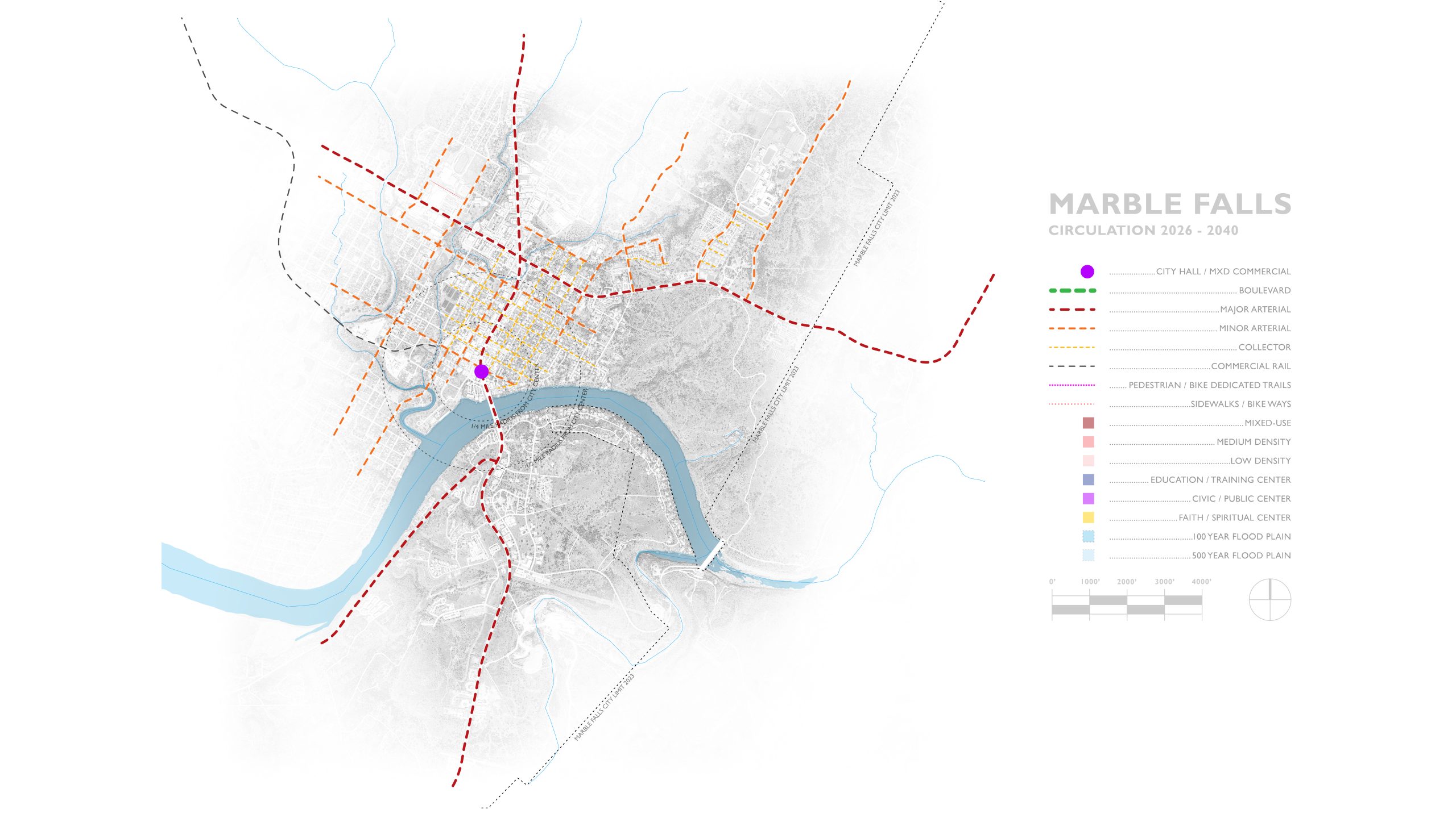
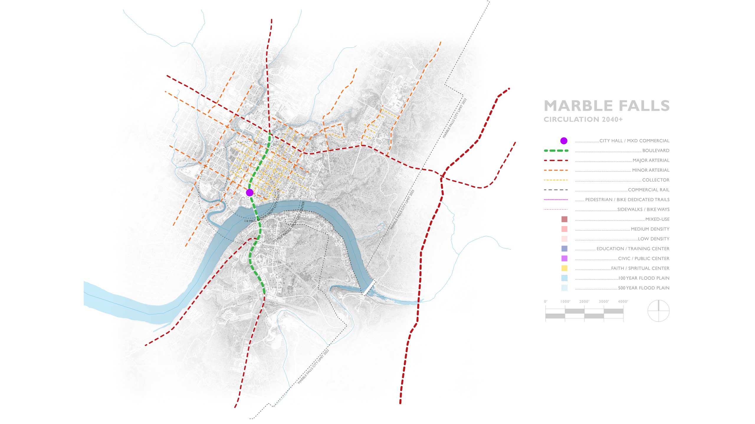
At the heart of this vision is the belief that successful communities are built around human-scale movement and interaction. Sidewalks, bicycle facilities, trails, and other forms of local circulation are not simply recreational amenities; they are essential components of community life, economic vitality, public health, and placemaking. By strengthening circulation systems throughout the historic core, Marble Falls can create a more connected, accessible, and resilient town center while supporting future growth in a manner that reinforces its unique Hill Country character and setting.
Open Space
The open space system proposed for Marble Falls is envisioned as a connected network of restored native landscapes, parks, trails, and civic spaces that form the ecological and social framework of the community. Following natural drainage corridors and topography, this living infrastructure manages stormwater, restores native habitat, and creates continuous pathways that link neighborhoods, downtown, and Lake Marble Falls.
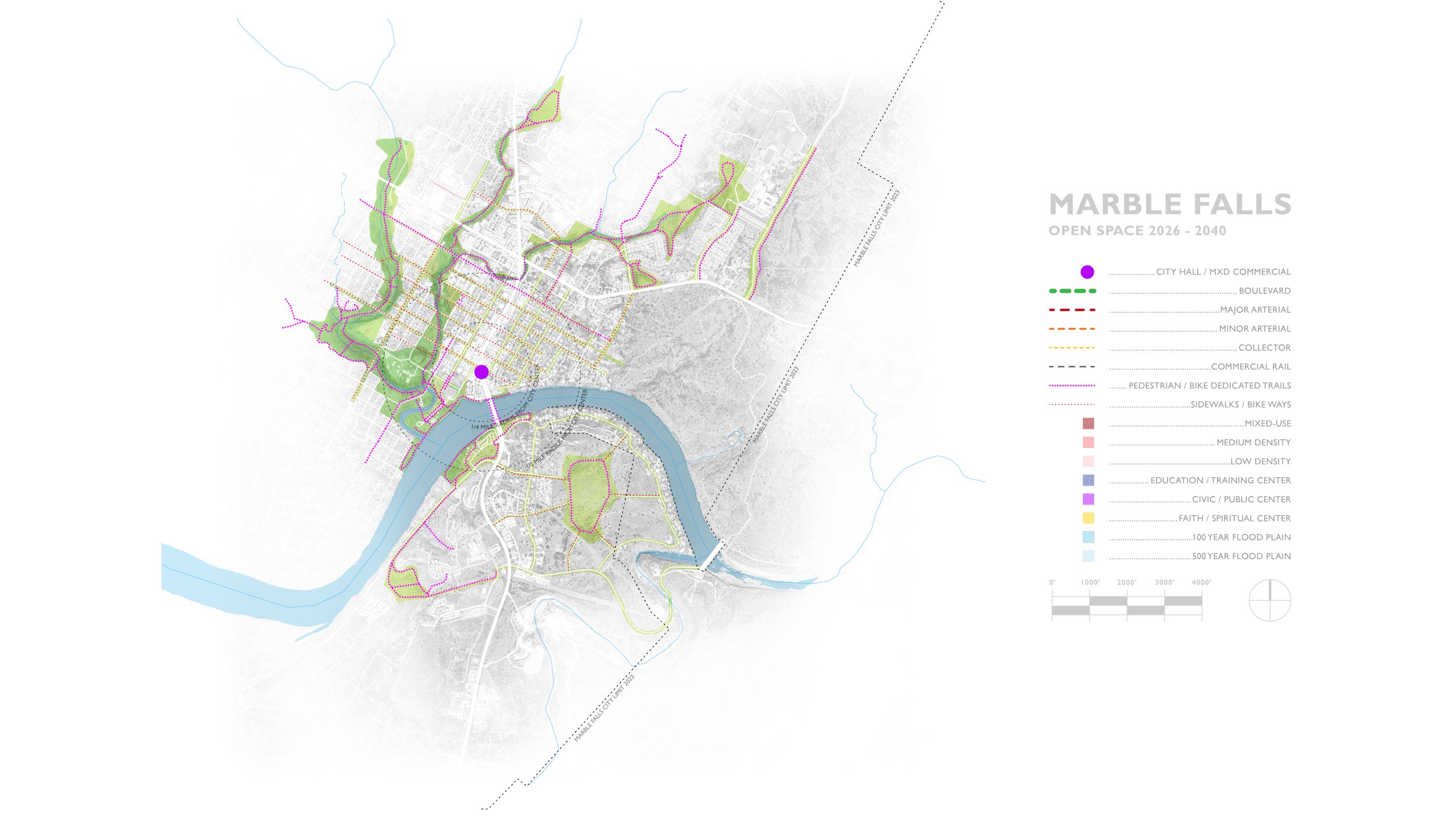
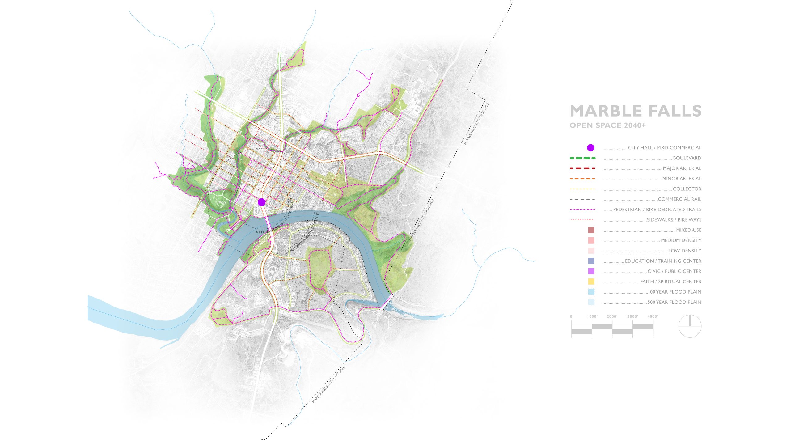
More than an environmental system, this network serves as an armature for future investment and community value. Parks, trails, and public spaces create memorable places, strengthen community identity, and establish a setting where nature, commerce, and daily life come together to define the character of Marble Falls.
Communities increasingly compete for residents, businesses, and investment based on the quality of their public realm. In this environment, parks, trails, natural landscapes, and connected public spaces are no longer amenities alone—they are essential economic and environmental infrastructure.
As Hill Country communities continue to evolve, those that offer exceptional public spaces, meaningful access to nature, and a strong sense of place will be best positioned to remain prosperous and resilient. A connected open space system is therefore not simply a community amenity—it is foundational infrastructure that contributes directly to the long-term economic, environmental, and civic health of Marble Falls.
LAND USE - A Flexible Framework for Growth
The land use framework proposed for Marble Falls is based on the premise that successful communities are often defined less by the separation of uses than by the quality of the places and spaces they create. Historically, many small towns accommodated homes, shops, offices, lodging, civic buildings, and workplaces within comfortable walking distance of one another, creating environments that were both economically adaptable and socially connected.
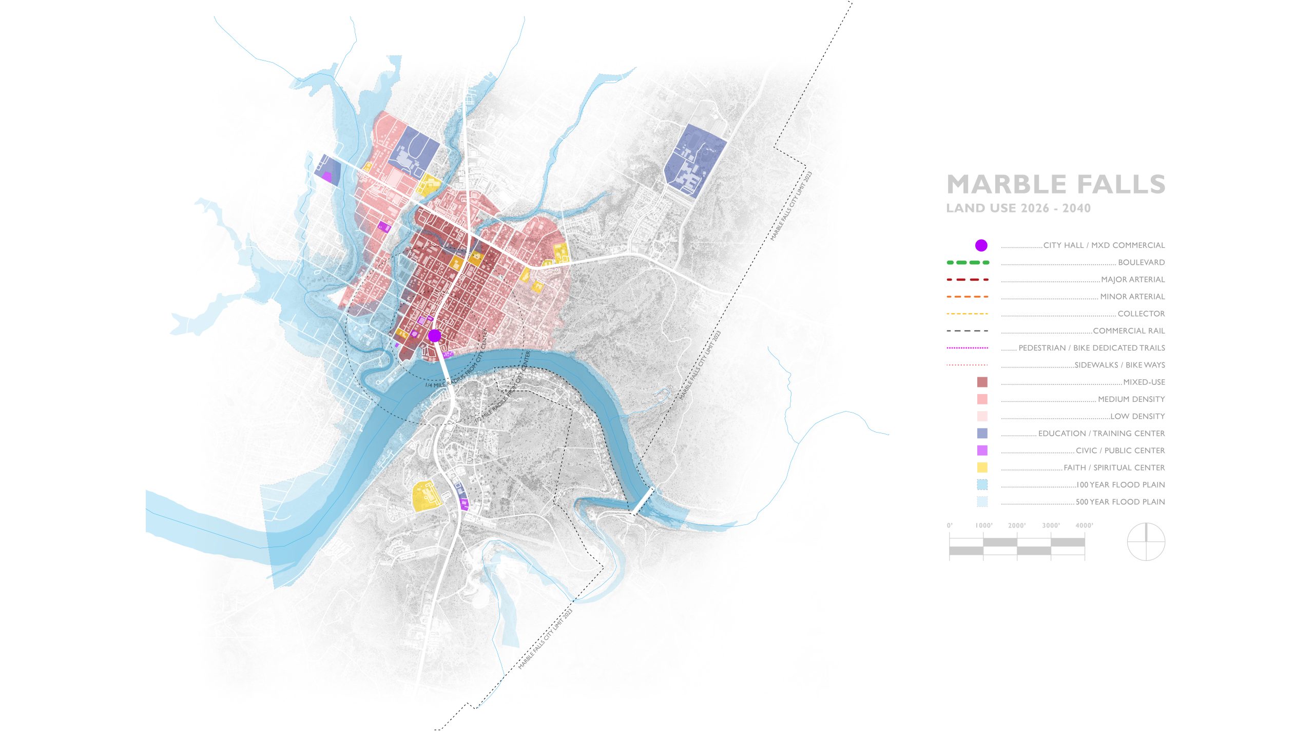
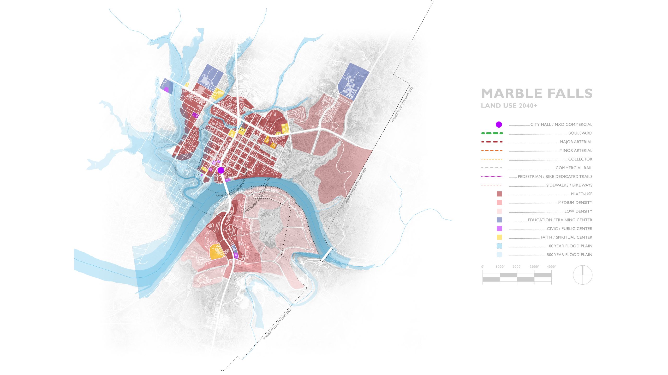
Rather than organizing future development around increasingly specialized land-use categories, this study explores a framework that allows a broad range of compatible uses throughout the historic core while maintaining a consistent pattern of well-designed streets, public spaces, and building forms. The objective is not to increase intensity for its own sake, but to create a development pattern capable of evolving over time as community needs change.
To support this approach, the plan proposes a transition from conventional Euclidian zoning toward a form-based framework. Traditional zoning primarily regulates land uses and often produces districts that are separated by function. Form-based zoning focuses instead on the relationship between buildings, streets, public spaces, and neighboring properties. Building placement, streetscape quality, pedestrian comfort, and compatibility with surrounding development become the primary organizing principles, while property owners retain greater flexibility in the specific uses they choose to pursue.
The plan generally envisions modest increases in development intensity within the historic core, with most buildings limited to three stories in height. This scale allows additional housing, employment, services, and commercial activity to be accommodated while preserving the human scale, development character, and public realm qualities that contribute to Marble Falls’ identity.
A Framework for the Next Generation: Marble Falls 2040
Taken together, the transportation, open space, land use, and civic infrastructure proposals illustrated in this study describe a long-range framework for the evolution and sustainability of Marble Falls' historic core. While each layer provides independent benefits, their greatest value emerges when considered as a coordinated system that aligns public investment, environmental infrastructure, multimodal mobility, and private development around a common vision for the future.
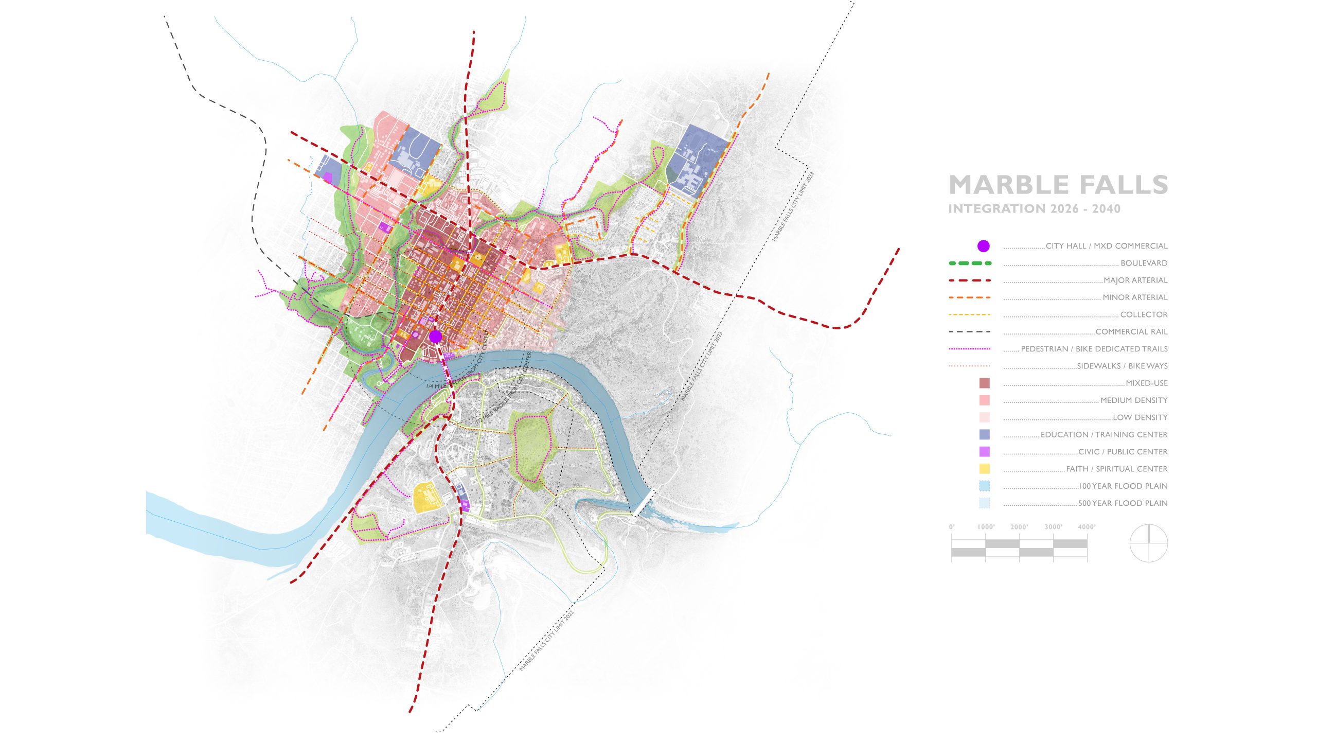
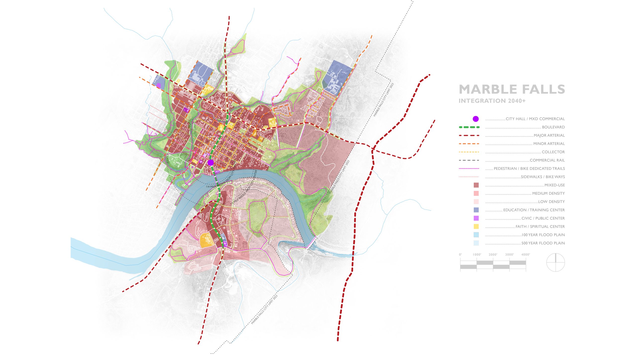
Central to this vision is the transformation of U.S. Highway 281 from a regional transportation corridor that divides the community into a redesigned civic boulevard that connects the core of the city. As future regional through traffic is gradually redirected to a new eastern crossing of the Colorado River, the existing corridor has the potential to evolve into a public boulevard lined with shops, services, workplaces, housing, and civic destinations. Rather than functioning as a barrier, the boulevard becomes the organizing spine of the historic core and a defining public space for the community.
Supporting this transformation is a connected network of parks, restored native landscapes, trails, and public spaces that provide environmental resilience, alternative transportation, and a memorable public realm. Together with a more walkable pattern of development and investment, this framework strengthens connections between downtown, neighborhoods, schools, the lakefront, and emerging redevelopment districts throughout the town center.
The plan also contemplates the long-range creation of a new City Center at the intersection of the future Avenue H Boulevard and 2nd Street. This location offers a unique opportunity to establish a civic and economic anchor at one of the most visible and strategically connected points within the community. Conceived as a public-private partnership, the center could combine future municipal facilities, professional offices, community gathering spaces, and supporting commercial uses within a single mixed civic district. A signature pedestrian crossing spanning the future boulevard would physically and symbolically reconnect the historic core and establish a recognizable civic landmark for Marble Falls.
The ideas presented here suggest how strategic public investment, environmental stewardship, and thoughtful urban design can work together to create a more connected, accessible, and vibrant community. The goal is not to abandon the qualities that have made Marble Falls successful, but to build upon them in ways that enhance daily life, strengthen economic opportunity, and create a more memorable and enduring Hill Country community.
Beyond the Highway
Beyond the Highway: Marble Falls is the first in a series of independent studies intended to explore the latent opportunities that exist within Texas Hill Country communities as they adapt to changing economic, environmental, and demographic conditions.
Over decades of work in rural communities and small towns across the country, we have observed that successful places rarely remain static. Communities either continue to invest in their future, adapting to changing circumstances and emerging opportunities, or they gradually become less competitive for residents, businesses, and investment. The most resilient communities are those that continually reimagine what they can become while building upon the strengths that made them successful in the first place.
We believe that Hill Country towns possess extraordinary assets—natural beauty, cultural identity, human scale, and strong community character—that position them to thrive in the decades ahead. The purpose of this study is not to predict the future, but to explore how thoughtful planning, strategic public investment, and intelligent patterns of development and redevelopment might transform those assets into lasting economic, environmental, and civic value for future generations.


